
Back in college, I did a research report in a sedimentology class on Boundry Layer Bedforms. Here's the idea, in a nutshell: when a strong current in the ocean goes across a very fine and unconsolidated sediment on the ocean floor (could also be a river), strange things can occur from the interaction with current and sediment at the interface between the two. Current alters sediment and sediment alters current. Any irregularity in the sediment changes the current. Here's a visual aid: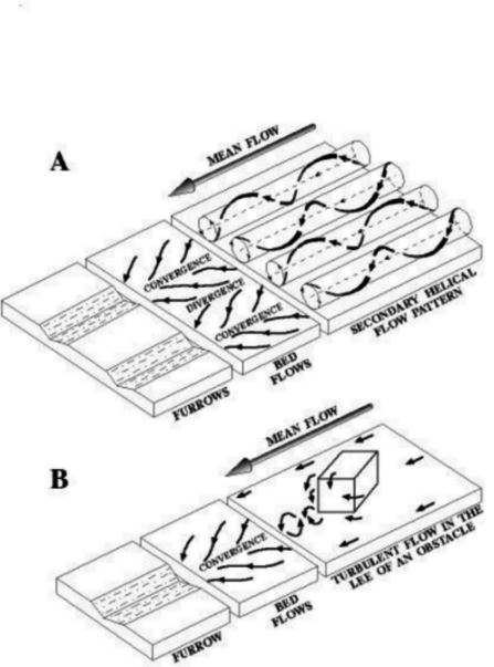
The upper part is what happens to a current passing over a flat surface. The lower part shows what results from an imperfection in that surface. See how linear channels are created? By the way, that image is from Survey Number 8--SIDESCAN SONAR IMAGES, SURFICIAL GEOLOGIC INTERPRETATIONS, AND BATHYMETRY OF NEW HAVEN HARBOR, CONNECTICUT, AND THE NEW HAVEN DUMPING GROUND, NORTH-CENTRAL LONG ISLAND SOUND
The more I look at these images, the less convinced I am that water is involved. Fluid, yes, in the form of wind. Using Google Earth in Mars Mode, I've been looking at some of the gullies on the walls of Newton Crater, and they are quite remarkable. They meander, and split, and fan out. But there are dunes inside them. Which is interesting.
I live at the very foot of the Rocky Mountains just outside the opening of a canyon. When the downslope winds are raging, I can actually watch the way the wind decants from the confines of the canyon and spill out on the plains by watching the way the trees bend.
What sort of patterns does the wind follow down that crater wall? How many weird bedforms will result from those currents interacting with that dry cold sediment on a steep slope interupted by jagged outcrops?
As for the change in color: eolean transport is very selective based upon wind speed. Small changes result in whole different clasts being transported, and how far. How do the winds change from season to season in this area? Are they upslope or downslope? Are we just seeing downslope movement of darker material brought by downslope winds?
There is something about the way these streaks are displayed that doesn't look quite right to me to be downslope movent of water/brine. It reminds me more of talus piles than gully deposits. I need stereo pairs or a contour map to really see if they are moving perpendicular to slope. That's important. Boundry layer bedforms would not be so constrained to slope.
There is also the notion of rock glaciers (90% rock, 10% ice), but that's another story.
Whopping big picture:
Note how the dark material originates far up the crater rim - not where it fans out below the outcrop!
Additional comment:
Wet sand is sculpted by the wind differently than dry sand. If this material is wet, and there is wind, then there should be sharp relief between the wet sand (which is hard to blow away) and the dry sand (which is easily eroded).
Space/Science » in reply to Re: More evidence of brine seeps on Mars?
Boundry Layer Bedforms